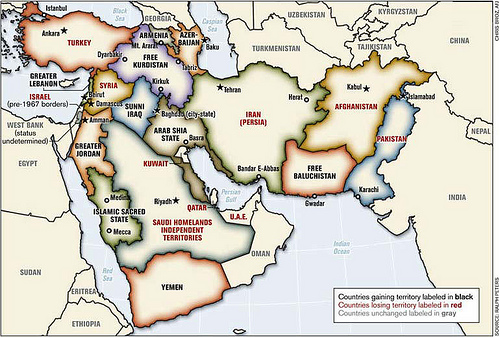
Remember the above map? It was drawn up by Infinite Star Armchair general Ralph “Blood ‘N Guts” Peters back in 2006 in the last flourish of neocon thriumphalism as the way to create a “better Middle East”. The idea apparantly being that since these borders were drawn up almost a century ago by a bunch of European imperialists and have caused a lot of trouble since, what better way to end this trouble by letting another bunch of imperialists, American this time, draw up another set of borders according to their prejudice and idee-fixes, because that worked out so well last time. Also, to stop ethnic cleansing by pre-emptively ethnic
cleanse these countries. At the time it seemed like a joke, if a sick one made palatable by the idea that Peters is such a loon he would be too over the top even for Dr Strangelove.
Guess what? The joke’s on us:
NEW YORK: A redrawn map of South Asia showing a truncated Pakistan, reduced to an elongated sliver of land, has sparked fear among military planners in Islamabad who think India and Afghanistan are “colluding” to destroy the only nuclear powered-Muslim nation with the US help, a media report said on Sunday.
The map, first circulated as a theoretical exercise in some American neoconservative circles, has fueled a belief among Pakistanis that what the United States really wants is the breakup of their country, the New York Times reported.
Pakistani people have reason to be paranoid about the USA’s intentions for their country, considering their mutual history, which includes enthusiastic American support for succesive Pakistani dictators, CIA backed meddling in Afghanistan during the eighties which helped destabilise Pakistan as well, not tomention the recent American airstrikes on Pakistan itself. It may look absurd now, but an invasion of Iraq looked absurd too, back in the nineties. That Obama will be president in January is no guarantee: Democrats are just as prone to stupid foreign policies: even Carter supported Somoza.
Found via Randy McDonald.